Real-Life Florida vs GTA 6

Compare iconic Florida landmarks with their in-game GTA 6 counterparts. From Ocean Drive to the Everglades and Florida Keys, see how Rockstar recreated the Sunshine State.

Total Landmarks
10 Locations
4 Main Regions
Confirmed in Trailers
4 Pairs
100% Confirmed
Spotted in Backgrounds
5 Pairs
Trailer Backgrounds
Expected Landmarks
1 Pairs
Community Matches
Side-by-Side Comparison · Real World vs GTA 6

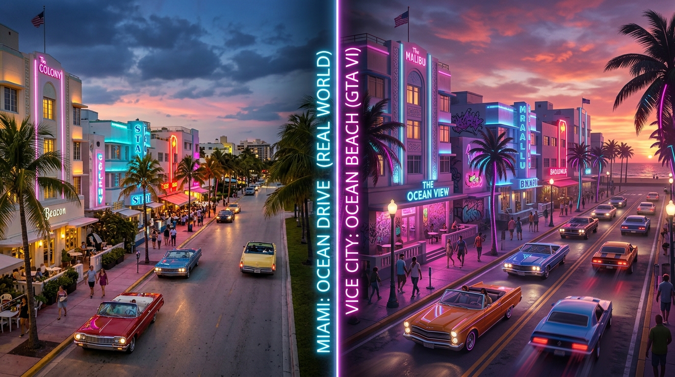
Miami Ocean Drive → Vice City Ocean Beach

Official Rockstar Location
Side-by-side comparison of Miami Ocean Drive vs Vice City Ocean Beach
// Architectural Homage: 1930s Art Deco Hotels, Neon Streamline Moderne Facades & Palm Promenades
View Ocean Beach on Map →
Showing 10 of 10 landmark comparisons
Real World (Florida)
Miami Beach / Ocean Drive
Miami-Dade County, FL · Iconic art deco hotels, pastel neon facades, beachfront promenade, and sports car cruising strip
→
GTA 6 In-Game
Ocean Beach / Vice Beach
Vice-Dale County (Vice City)

Visible in Trailer 1 opening sequences. Exact architectural homages to South Beach classics including Colony Hotel, Clevelander, and beachfront palm walkways.

► Trailer 1 (0:04) — Sunset convertible cruise along Ocean Drive strip
25.8°N 80.2°W
RADAR
Official
25.762°N, 80.192°W
Locate on Map →
Real World (Florida)
Wynwood Walls & Arts District
Downtown Miami, FL · Outdoor mural galleries, urban graffiti, converted warehouses, and trendy bohemian cafes
→
GTA 6 In-Game
Little Haiti / Wynwood Murals
Vice-Dale County (Vice City)

Distinct street art murals and lowrider vehicle meets showcased in trailer nightlife sequences, reflecting modern Miami cultural revitalization.

► Trailer 1 (0:33) — Nighttime lowrider hydraulics meet with vibrant graffiti backdrops
25.8°N 80.2°W
RADAR
Observed
25.801°N, 80.199°W
Locate on Map →
Real World (Florida)
Venetian Islands & Biscayne Bay
Biscayne Bay Causeway, FL · Private man-made barrier islands connected by toll causeways with luxury residences
→
GTA 6 In-Game
Venetian Islands Gated Enclaves
Vice-Dale County (Vice City)

Ultra-exclusive residential mansions with private deep-water yacht docks, security guard gates, and waterfront swimming pools overlooking the skyline.

► Trailer 1 (0:18) — Aerial speed boat wake crossing Biscayne Bay waterways
25.8°N 80.2°W
RADAR
Observed
25.791°N, 80.165°W
Locate on Map →
Real World (Florida)
Daytona International Speedway
Volusia County, FL · World-famous 2.5-mile tri-oval asphalt superspeedway and motorsports Mecca
→
GTA 6 In-Game
Vice City Motor Speedway
Vice-Dale County (Vice City)

Grandstand facilities and stock car racing circuits located northwest of Vice City, hosting sanctioned asphalt circuits and demolition derbies.

► Leaked dev files & telemetry pins — Multi-tier asphalt oval stadium complex
25.8°N 80.3°W
RADAR
Observed
25.820°N, 80.250°W
Locate on Map →
Real World (Florida)
The Florida Everglades
South Florida Wetland Basin · Subtropical wetland sanctuary, sawgrass prairies, mangrove labyrinths, and marsh sloughs
→
GTA 6 In-Game
Grassrivers Wetland Sanctuary
Kelly County (Grassrivers)

Features high-speed fan airboats, alligators basking on mudbanks, invasive Burmese pythons, and redneck mud-bogging tracks in Kelly County.

► Trailer 1 (0:09) — High-speed twin-fan airboat cutting through sawgrass sloughs
25.6°N 80.6°W
RADAR
Official
25.640°N, 80.590°W
Locate on Map →
Real World (Florida)
Big Cypress National Preserve
Collier County Buffer, FL · Vast temperate bald cypress swamps, elevated timber boardwalks, and backcountry wilderness
→
GTA 6 In-Game
Kelly County Cypress Swamps
Kelly County (Grassrivers)

Dense moss-draped bald cypress hammocks, off-grid hunter cabins, moonshine stills, and dirt 4x4 trails treacherous to standard road vehicles.

► Trailer 1 (0:46) — Mud club monster truck rally with spectators cheering in the slough
25.9°N 80.8°W
RADAR
Observed
25.850°N, 80.800°W
Locate on Map →
Real World (Florida)
Alligator Alley (I-75 Interstate)
Collier & Broward Counties, FL · Trans-peninsular toll interstate slicing 80 miles through continuous alligator wetlands
→
GTA 6 In-Game
Interstate 97 Everglades Expressway
Kelly County (Grassrivers)

A multi-lane toll highway cutting directly across Leonida, featuring fencing barriers, wildlife underpasses, and remote service plazas.

► Trailer 1 (0:12) — Dual-carriageway highway straightaway flanked by swamp channels
25.8°N 80.7°W
RADAR
Official
25.780°N, 80.700°W
Locate on Map →
Real World (Florida)
Seven Mile Bridge & Overseas Hwy
Monroe County, Florida Keys · Engineering marvel bridging turquoise ocean flats between the Middle and Lower Keys
→
GTA 6 In-Game
Leonida Keys Ocean Viaducts
Mariana County (Leonida Keys)

Expansive multi-span concrete highway viaducts spanning turquoise open ocean, alongside the abandoned parallel rail bridge ruins.

► Trailer 1 (0:22) — Aerial ocean perspective of long highway spans over coral shallows
24.7°N 81.2°W
RADAR
Observed
24.700°N, 81.150°W
Locate on Map →
Real World (Florida)
Key West Historic Seaport & Mallory Sq
Key West Harbor, FL · Conch architecture, pastel weatherboard homes, sunset celebration piers, and sportfishing docks
→
GTA 6 In-Game
Bahia Keys Sportfishing Haven
Mariana County (Leonida Keys)

The southernmost settlement in Leonida, featuring open-air tiki bars, dive charter slips, historic wooden bungalows, and sunset tourists.

► Trailer 1 (0:24) — Waterfront tiki bar dock with sports boats moored at sunset
24.6°N 81.8°W
RADAR
Official
24.550°N, 81.780°W
Locate on Map →
Real World (Florida)
Port Everglades & Container Docks
Fort Lauderdale (Broward County), FL · Deepwater container seaport, crude oil storage farm, and multimodal freight rail yard
→
GTA 6 In-Game
Port Gellhorn Freight Terminal
Leonard County (Port Gellhorn)

Heavy industrial logistics center featuring towering gantry cranes, oil tank farms, industrial railyards, and contraband cargo routes.

► Leaked dev coordinate captures & trailer background harbor cranes
26.1°N 80.1°W
RADAR
Estimated
26.085°N, 80.115°W
Locate on Map →

Are Other Major Florida Cities in GTA 6?

Direct, honest answers to recurring search queries regarding Florida metropolitan areas and regional analogs.

• Is Orlando in GTA 6?

Not directly represented as a distinct standalone metropolis. However, central Leonida farmlands (Ambrosia) and parody roadside amusement parks reflect Central Florida tourism culture without a 1:1 Orlando replica.

• Is Tampa in GTA 6?

There is no confirmed city named "Tampa." Community cartographers suggest Port Gellhorn and western coastal districts incorporate elements of the Tampa Bay / Gulf Coast commercial zones.

• Is Jacksonville in GTA 6?

Jacksonville does not appear in known trailer files or leak documents. Northern Leonida is bounded by fictional highland terrain (Mount Kalaga) rather than North Florida cities.

• Is Key West in GTA 6?

Yes — the southernmost settlement in the Leonida Keys is heavily modeled after Key West, featuring conch-style heritage bungalows, sunset piers, and sportfishing docks.

• Is Fort Lauderdale represented?

Port Gellhorn and northern canal corridors serve as the architectural and industrial analog to Broward County and Fort Lauderdale.

• Is Fort Myers in GTA 6?

Fort Myers is not named directly. However, the Gulf Coast barrier islands, fishing piers, and marina communities of western Leonida draw clear visual inspiration from Lee County and Fort Myers Beach.

• Is Naples in GTA 6?

Naples is not explicitly named. Its luxury Gulf Coast demographic, championship golf estates, and exclusive waterfront canals are satirized in the affluent coastal enclaves of Catalan Key and Rockridge.

• Is Broward County in GTA 6?

Broward County is satirized through a mix of Kelly County and northern Vice-Dale, featuring extensive suburban drainage canals, industrial rail corridors, and container ports inspired by Port Everglades.